Why there are sea monsters lurking in early world maps
16th and early 17th century maps hint at how people’s perception of the ocean has changed over time
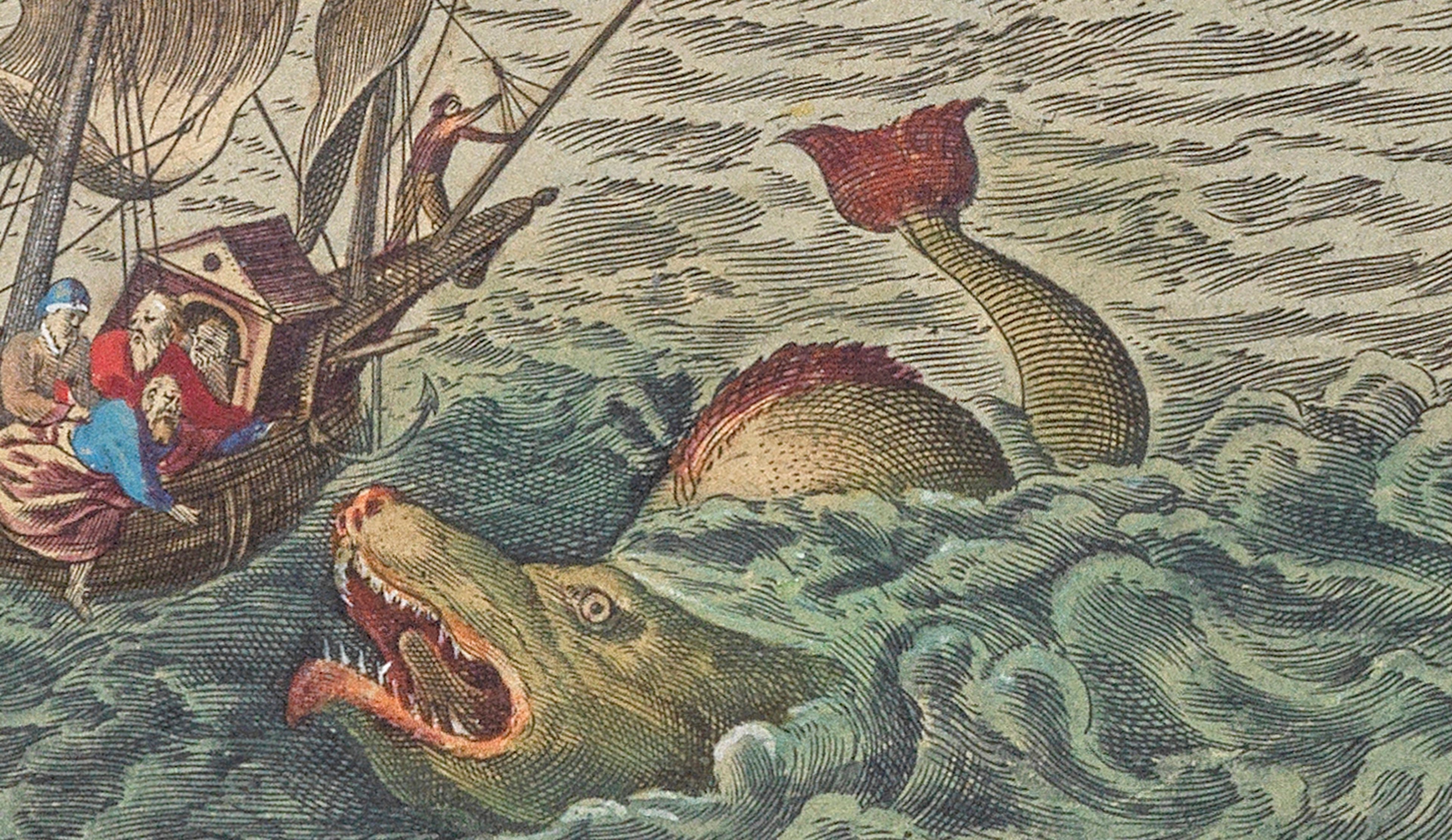
Sea monsters
Sea monsters have long captured the human imagination, appearing as fearsome creatures on ancient nautical maps. These mythical beings, often depicted with serpentine bodies and monstrous features, served as both warnings and wonders to early mariners. From the kraken to the leviathan, each sea monster told a story of the unknown depths of the ocean. This page delves into the fascinating world of these legendary creatures, exploring their origins, symbolism, and the role they played in maritime lore. Join us as we navigate through history, uncovering the mysteries of sea monsters on old maps.
- Bullet 1
- Bullet 2
- Bullet 3
- List item
- List item
- List item

Colourful maps (link to different map)
Ronkeltoef fefe feff
Sea monsters have been a fascinating and enduring element of cartography for centuries. From medieval maps to the Age of Exploration and beyond, sea monsters have been depicted in various forms and styles on maps, capturing the imagination of cartographers and map enthusiasts alike. In this article, we'll explore the history of sea monsters on maps, their significance, and their enduring appeal.
The earliest known examples of sea monsters on maps date back to the medieval period, when maps were used primarily as navigational tools. These monsters were typically depicted as fierce creatures, often with multiple heads, sharp teeth, and serpentine bodies. They were placed in areas of the map that were believed to be unexplored or dangerous, and served as warnings to sailors of potential hazards in the waters ahead.
Sea monster illustrations on maps were not always meant to be taken literally. In some cases, they were used to symbolize political or religious concepts. For example, the sea serpent was sometimes used to represent the devil, while the whale was often used to symbolize the biblical story of Jonah and the whale.
The use of sea monster illustrations on maps declined in the 17th century as cartography became more advanced and accurate. However, they continued to be used in works of art and literature well into the 19th and 20th centuries. Today, sea monsters on old maps are considered fascinating examples of the intersection between art, science, and mythology.


Caption - optional caption can be placed here (with link)

text

text
Sea monsters have been a fascinating and enduring element of cartography for centuries. From medieval maps to the Age of Exploration and beyond, sea monsters have been depicted in various forms and styles on maps, capturing the imagination of cartographers and map enthusiasts alike. In this article, we'll explore the history of sea monsters on maps, their significance, and their enduring appeal.
The earliest known examples of sea monsters on maps date back to the medieval period, when maps were used primarily as navigational tools. These monsters were typically depicted as fierce creatures, often with multiple heads, sharp teeth, and serpentine bodies. They were placed in areas of the map that were believed to be unexplored or dangerous, and served as warnings to sailors of potential hazards in the waters ahead.
Sea monster illustrations on maps were not always meant to be taken literally. In some cases, they were used to symbolize political or religious concepts. For example, the sea serpent was sometimes used to represent the devil, while the whale was often used to symbolize the biblical story of Jonah and the whale.
The use of sea monster illustrations on maps declined in the 17th century as cartography became more advanced and accurate. However, they continued to be used in works of art and literature well into the 19th and 20th centuries. Today, sea monsters on old maps are considered fascinating examples of the intersection between art, science, and mythology.
This collection is a small contribution to a better understanding of human endeavour and the development of thought, a never ending story ”
- Neil Sunderland
full screen image
different text colums
Maps were often decorated with elaborate illustrations, and sea monsters were a popular motif. They added visual interest and helped to fill the empty spaces on the map.
Many regions of the world were still unexplored during the medieval period, and maps often included fanciful illustrations to represent the unknown and mysterious lands beyond the known world. Sea monsters were one way to symbolize the dangers and uncertainty of these uncharted waters.
Sea monsters have been part of human mythology and folklore for thousands of years. They were often associated with the supernatural and the unknown, and their inclusion on maps reflected the belief that the sea was a place of mystery and danger.


Drag to compare
comparison
Sea monsters have been part of human mythology and folklore for thousands of years. They were often associated with the supernatural and the unknown, and their inclusion on maps reflected the belief that the sea was a place of mystery and danger.

Hondius Sea monster
Sea monsters have been a fascinating and enduring element of cartography for centuries. From medieval maps to the Age of Exploration and beyond, sea monsters have been depicted in various forms and styles on maps, capturing the imagination of cartographers and map enthusiasts alike. In this article, we'll explore the history of sea monsters on maps, their significance, and their enduring appeal.
The earliest known examples of sea monsters on maps date back to the medieval period, when maps were used primarily as navigational tools. These monsters were typically depicted as fierce creatures, often with multiple heads, sharp teeth, and serpentine bodies. They were placed in areas of the map that were believed to be unexplored or dangerous, and served as warnings to sailors of potential hazards in the waters ahead.
Sea monster illustrations on maps were not always meant to be taken literally. In some cases, they were used to symbolize political or religious concepts. For example, the sea serpent was sometimes used to represent the devil, while the whale was often used to symbolize the biblical story of Jonah and the whale.
The use of sea monster illustrations on maps declined in the 17th century as cartography became more advanced and accurate. However, they continued to be used in works of art and literature well into the 19th and 20th centuries. Today, sea monsters on old maps are considered fascinating examples of the intersection between art, science, and mythology.

This is an old watch
The Sunderland Collection stands as a remarkable testament to the power of exploration, cartography, and the preservation of historical knowledge. Comprising a vast array of old atlases, this collection represents a rich tapestry of human understanding of the world throughout various periods in history. From ancient civilizations to the age of discovery and beyond, the Sunderland Collection offers a unique opportunity to delve into the evolution of maps and the ways in which they shaped our perception of the world. In this essay, we will explore the significance of the Sunderland Collection and the invaluable insights it provides into the history of cartography.
I. The Origins of the Sunderland Collection: A. The Sunderland Family: The origins of the collection can be traced back to the Sunderland family, who were avid collectors of atlases and maps throughout the 18th and 19th centuries. B. Robert Sutton and Alexander Wilkinson: The collection was further expanded through the efforts of Robert Sutton and Alexander Wilkinson, who acquired and added numerous atlases to the collection during the late 19th and early 20th centuries.
II. The Scope and Significance of the Collection: A. Vast Historical Range: The Sunderland Collection encompasses atlases spanning various periods, from medieval maps to the Renaissance, the age of exploration, and beyond, offering a comprehensive overview of the evolving understanding of geography. B. Cultural and Historical Insights: Each atlas within the collection provides a window into the cultural, political, and scientific perspectives of the time in which it was created, offering invaluable insights into the worldview of past societies. C. Evolution of Cartography Techniques: The Sunderland Collection showcases the progression of cartography techniques, from early hand-drawn maps to the introduction of printing techniques and the incorporation of new geographical knowledge.
III. Notable Atlases within the Collection: A. Ptolemy's "Geographia": The Sunderland Collection includes several editions of Ptolemy's "Geographia," a seminal work in the history of cartography that shaped European perceptions of the world for centuries. B. Mercator's "Atlas": Gerhard Mercator's "Atlas" is a notable inclusion, known for its innovative projection system that facilitated accurate navigation and greatly influenced subsequent mapmaking. C. Blaeu's "Atlas Maior": Joan Blaeu's "Atlas Maior" is a renowned atlas that featured elaborate illustrations and detailed maps, exemplifying the craftsmanship and artistry of the period.
IV. The Legacy and Importance of the Sunderland Collection: A. Historical Preservation: The Sunderland Collection serves as a vital resource for scholars, researchers, and historians, preserving invaluable knowledge about the world's past perceptions. B. Educational Value: The collection offers unique educational opportunities, allowing students and enthusiasts to explore the evolution of cartography, understand cultural contexts, and appreciate the craftsmanship behind these old atlases. C. Inspiration for Contemporary Cartographers: The Sunderland Collection inspires contemporary cartographers to build upon the knowledge and techniques of the past while exploring new frontiers in mapping and geospatial visualization.
Conclusion: The Sunderland Collection stands as a treasure trove of old atlases, providing a captivating journey through the history of cartography. By studying these ancient maps, we gain a deeper understanding of how human knowledge and exploration have shaped our understanding of the world. The collection's vast historical range, cultural insights, and demonstration of evolving cartographic techniques make it an invaluable resource for scholars, educators, and anyone intrigued by the beauty and complexity of maps. As we continue to push the boundaries of geographical knowledge, the Sunderland Collection serves as a reminder of the enduring power of maps to inform, inspire, and connect us to our shared past.


Old hemisphere maps often feature intricate illustrations of sea monsters, adding a touch of myth and mystery to the cartography. These fantastical creatures were believed to inhabit uncharted waters, symbolizing the unknown dangers of the seas. The detailed artwork not only served as a warning but also showcased the mapmaker's artistic skill and imagination.
Mapping Innovations Symposium
Join us for a day of exploration into the art and science of cartography at the Mapping Innovations Symposium. This event will feature expert speakers discussing the latest advancements in map-making, from historical perspectives to digital innovations.
Book tickets| 0915 - 0945 | Registration and Coffee (Blackwell Hall) |
| 1000 - 1015 | WelcomeRichard Ovenden, OBE |
| 1015 - 1200 | Panel and Q&A: The art of cartography and new evidenceSpeakers: John Barrett-Material evidence of the surface of objects Lead Photographer at ARCHIOX Nick Millea - Spectacular! A digital exploration of the Gough Map Map Curator at Bodleian Libraries Yossef Rapoport - The Greatest Medieval Map-Maker: Al-Sharif al-Idrisi and Roger's Silver Disc Professor of Islamic History at Queen Mary University, London Dr. Sanne Frequin-A Ship's Globe in the Centraal Museum, Utrecht Assistant Professor of Humanities and Art History, University of Utrecht Chairperson: Judith Siefring Head of Digital Collections Discovery at Bodleian Libraries |
| 1200 - 1230 | Coffee Break (Blackwell Hall) |
| 1230 - 1300 | Bruce Mau- Nesting Globes: visualising the current global situationArchitect, designer, and educator |
| 1300 - 1400 | Lunch Break (Blackwell Hall)During lunch, there will be an exhibition and demonstration of the Selen Photometric Stereo System with its designer, Jorge Cano. |
| 1400 - 1545 | Panel and Q&A - Mapping in a digital worldSpeakers: Dr. Katherine McDonough - Map Search: using Al to explore map content Lecturer in Digital Humanities at Lancaster University; Senior Research Fellow and head of the Machines Reading Maps Project at The Alan Turing Institute
Professor of Digital Humanities at École Polytechnique fédérale de Lausanne (EPFL), Switzerland; Director of the Laboratory of Experimental Museology.
Geospatial technologist and Google evangelist
|
| 1545 - 1600 | ConclusionsAdam Lowe |
Simple event
| 1000 - 1200 | Morning symposium |
| 1200-1300 | Lunch |
| 1300-1500 | Afternoon Q&A |


Signup for our newsletter!
Would you like to learn more about sea monsters? Or do you have another story to share with us? Please contact us using this form.